Karawara Vision
Karawara Pedestrian and Cycle Access Plan
At the February 2025 Ordinary Meeting of Council, the Karawara Pedestrian and Cycle Access Plan (KPACAP) was adopted subject to Pedestrian Access Way No. 30 (between Beenan Close and Yallambee Place) being modified to ‘Non-Essential’. The Council Report containing the Pedestrian and Cycle Access Plan, and recommendations to improve infrastructure in the PAWs is available on the Council Meetings and the City’s consultation page.
The KPACAP has been referred for endorsement to the Department of Planning, Lands and Infrastructure in accordance with the Procedure for the Closure of Pedestrian Access Way Planning Guidelines.
The KPACAP has been prepared to provide a framework to assess future requests to alter Pedestrian Access Ways (PAW) in Karawara, as well as guide future decisions relating to infrastructure and maintenance. It identifies existing pedestrian and cycle access ways in Karawara with its study area including Curtin Primary School and Meath Care.
A total of 32 PAWs, also known as laneways, have been identified as part of the study. The City has developed a classification system to identify if each laneway/PAW is essential or non-essential in terms of how it’s used by pedestrians and cyclists in Karawara:
- Essential - the PAW should be retained and kept open because it plays an essential role in connecting people to places.
- Non-essential - the PAW could be closed without causing significant disadvantage when connecting people to places.
The KPACAP is an action of the City’s Integrated Transport Plan and has been prepared in accordance with the Western Australian Planning Commission’s (WAPC) endorsed Procedure for the Closure of Pedestrian Access Ways – Planning Guidelines (2009).
Public Access Way closure between Yallambee Place and Koolunda Court
At its December 2020 meeting, Council considered a petition requesting the closure of a PAW located between Yallambee Place and Koolunda Court, Karawara (a site plan is available). It was resolved to progress the closure of this PAW in 2021. The Council report and resolution is available on the Council Meetings page.
The City further investigated the proposed closure in accordance with Option B of the Department of Planning, Lands and Heritage (DPLH) guidelines - PAW closure where there is no endorsed pedestrian and cycle access plan. The draft Closure Report was endorsed at the 26 April 2022 Ordinary Meeting of Council. The Department of Planning, Lands and Heritage and Western Australian Planning Commission endorsed the proposal in October 2022.
The matter is currently with the Department of Lands for processing under the Land Administration Act 1987.
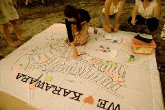
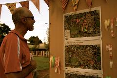
The Karawara Public Open Space Master Plan and Collaborative Action Plan was developed through significant community engagement, including informal workshops, Aboriginal community focus sessions, a pop-up discussion trail and drop-in events.
The vision for the project is ‘working together to strengthen Karawara’s public open space and community character.’
Project principles
- Building on Karawara character: Retain, enhance and actively build upon local spatial character attributes and seek to build upon the growing community capacity (pride)
- Connectivity: Seek to retain and enhance existing important linkages throughout Karawara and to adjoining suburbs
- Amenity: To incorporate amenity that reflects the landscape character and offers diversity of multiuse areas to foster community interaction
- Safety and security: Continue to build upon developing a safe and welcoming environment.
The purpose of the Collaborative Action Plan is to provide the community and stakeholders, in conjunction with the City of South Perth, an agreed project list that can be collectively implemented. The implementation of each project is based on timing and priorities that may also require specialists, either from the City or external consultants, to aid in the design and implementation of each project.
The Masterplan incorporates 14 projects that aim to strengthen Karawara’s public open space and community character.
Since implementation commenced in 2013, the majority of project actions have been addressed. The remaining actions are for a wayfinding strategy to be designed and implemented through the Pedestrian Access Ways (PAWs) and to investigate and trial the installation of permeable fencing along rear property boundaries.
Keep up to date
To keep up to date on what is happening in your local area, subscribe to the City’s eNewsletter.
Related documents
Contact us
- Phone 9474 0777
- Email enquiries@southperth.wa.gov.au