

Canning Bridge Activity Centre Plan
On 18 April 2016, the Western Australian Planning Commission approved the Canning Bridge Activity Centre Plan (ACP).
The Canning Bridge ACP sets out the City’s strategic vision and statutory planning requirements for development in the precinct surrounding the Canning Bridge Station on both sides of the Canning River and comprising land within both the City of Melville and the City of South Perth.
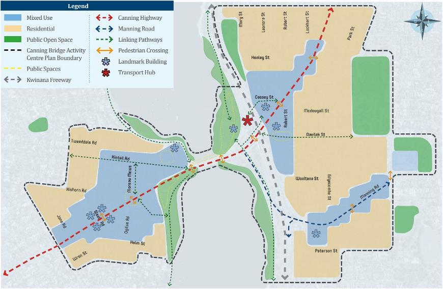
The Canning Bridge Activity Centre Plan (CBACP) is guided by the Canning Bridge Precinct vision statement:
The Canning Bridge area will evolve to become a unique, vibrant, creative community centred on the integrated transport node of the Canning Bridge station. The area will be recognised by its unique location, its integrated mix of office, retail, residential, recreational and cultural uses that create areas of excitement, the promotion of its local heritage and as a pedestrian friendly enclave that integrates with the regional transport networks while enhancing the natural attractions of the Swan and Canning Rivers.
Canning Bridge Rail Station Precinct Study and Vision
The Canning Bridge Precinct Vision was developed in response to State planning strategies aimed at accommodating population growth and was endorsed by the Councils of the Cities of South Perth and Melville, and subsequently by the Western Australian Planning Commission (WAPC), in 2010.
Initiated by the City of South Perth in 2006, the planning process examined opportunities to accommodate a diverse mix of land uses, housing and employment around the Canning Bridge Station precinct, capitalising on its role as a major public transport hub linking the Perth-Mandurah rail line and key east-west bus routes. The study area extended approximately 800 metres from the station, representing a ten-minute walk catchment.
The resulting Canning Bridge Rail Station Precinct Study was undertaken in partnership with the WAPC and the City of Melville and led to the endorsement of the Canning Bridge Precinct Vision as the preferred framework for future development.
A multi-agency working group was subsequently established to oversee its implementation. The Vision received the 2011 Planning Institute of Australia (WA) Award for Excellence for Best Large Project in recognition of its approach to activity centre regeneration and transit-oriented development.
Public Transport
Canning Bridge Station is located within the City of South Perth, directly under the Canning Highway Bridge and within the Kwinana Freeway reserve. It is the first station south of the Perth CBD with the location highly valued as a transfer point as the nexus of the Perth to Mandurah railway and major east-west bus routes. The rail station site is constrained by the relatively narrow Kwinana Freeway reserve, which limits opportunities for associated urban development in close proximity to the station.
The Canning Bus Bridge Interchange has been identified for upgrade and expansion to meet the requirements of existing and future passengers. Information on works is available on the Department of Transport’s website including a preliminary design which focusses on ensuring the bus interchange and road/path improvements work together to provide essential upgrades for bus, road and path users.
Canning Bridge Activity Centre Plan project timeline
| Milestone | Status |
|---|---|
Study of the precinct surrounding the Station on both sides of the Canning Bridge | 2006 |
Canning Bridge Rail Station Precinct Study | 2007-2010 |
| Report for the Canning Bridge Precinct Vision | 2010 |
| Establishment of a working group to oversee the production of the Canning Bridge Activity Centre Plan (CBACP). | 2010 |
| Modifications to the City of Melville side of the Canning Bridge ACP were endorsed by Melville’s Council | 17 March 2015 |
| Subsequently approved by the Western Australia Planning Commission | April 2016 |
| Minister for Planning approved City of South Perth local planning scheme Amendment No. 47 to former Town Planning Scheme No. 6 | 1 February 2017 |
| Ordinary Meeting of Council resolution to commence a formal review to ensure that it was operating in accordance with its goals and objectives | 28 August 2018 |
| Modifications to Canning Bridge ACP were endorsed by at Ordinary Meeting of Council | 25 February 2020 |
| Following a period of community engagement, the draft Canning Bridge Activity Centre Plan was submitted to the WA Planning Commission | May 2023 |
| Modifications to the City of Melville side of the Canning Bridge ACP were submitted to the Western Australia Planning Commission | May 2023 |
| Subsequent resolution is pending | July 2026 |
An activity centre is an area where there is a concentration of commercial, retail (including shopping, cafes, restaurants and bars) and residential land uses. Due to the land uses in activity centres, they are also focal points in the transport network.
State Government planning policies encourage development in activity centres to improve services and business opportunities, increase housing close to jobs and services, and to improve the sustainability of the transport network by supporting walking, cycling and public transport.
The State Government has organised the activity centres within metropolitan Perth into a hierarchy, to inform and help coordinate the planning of these important areas. There are 50 activity centres within the central sub-region of Perth, with the central business district being the largest.
Canning Bridge is classified as a district centre. District centres have a focus on servicing the daily and weekly needs of residents. They should aim to provide a local community focus and provide services, facilities and job opportunities that reflect the particular needs of their catchments. In Canning Bridge, this includes recognising the location of the area on the Canning River, its excellent public transport offering as well as its accessibility and liveability.
An Activity Centre Plan (ACP) is a document that provides the guiding framework for the planning and development of an activity centre. It does this by setting out the strategic vision for an area and the statutory planning requirements for development. An ACP guides the types of land uses and the overall development (including built form) that is intended to occur within the activity centre. It can detail land uses, environmental assets, residential density, built form, infrastructure and access arrangements.
ACPs are developed in accordance with the Planning and Development (Local Planning Schemes) Regulations 2015 (Regulations). Approval for an ACP is the responsibility of the Western Australian Planning Commission (WAPC).
A precinct structure plan describes the intended zoning and subdivision pattern for a land area. Depending on the scale, a precinct structure plan identifies a pattern for street blocks, roads and open space together with proposed zones or land uses and major transport or utility infrastructure. A precinct structure plan provides development guidance for the built form and public realm.
A structure plan describes the intended zoning and subdivision pattern for a land area. Depending on the scale, a structure plan identifies a pattern for street blocks, roads and open space together with proposed zones or land uses and major transport or utility infrastructure.
A precinct structure plan is a more comprehensive document that addresses all the matters in a (standard) structure plan, and in addition, provides development guidance for the built form and public realm.
Commencing in 2027, the City will bring the Canning Bridge ACP in line with the recently endorsed ‘manner and form’ document requirements of the Western Australian Planning Manual Guidance for Structure Plans. This will not involve proposing material changes to the requirements of the CBACP.
The Vision statement highlights the main objectives of the precinct:
The Canning Bridge area will evolve to become a unique, vibrant, creative community centred on the integrated transport node of the Canning Bridge rail station. The area will be recognised by its unique location, its integrated mix of office, retail, residential, recreational and cultural uses that create areas of excitement, the promotion of its local heritage and as a pedestrian friendly enclave that integrates with the regional transport networks while enhancing the natural attractions of the Swan and Canning Rivers.
This is a long term plan that anticipates development taking place up to 2051. Development is both private and public (infrastructure).
Over the life of the plan there will be reviews and changes that might occur to respond to future community needs.
Future review 2027
Commencing in 2027, the City will bring the Canning Bridge ACP in line with the recently endorsed ‘manner and form’ document requirements of the Western Australian Planning Manual Guidance for Structure Plans. No material changes to the requirements of the CBACP will be proposed as part of this process.
Previous review 2018/20
For the City of South Perth side of the Canning Bridge ACP, the most recent review through a comprehensive process undertaken between 2018 and 2020.
In 2018, Council resolved to initiate a formal review of the CBACP to assess whether the Plan continued to operate effectively and achieve its intended objectives. A comprehensive community engagement program was undertaken to provide stakeholders with opportunities to contribute to the review and inform proposed amendments.
The consultation process generated a strong level of community participation, with more than 230 submissions received and almost 100 attendees participating in information and feedback sessions. To further support the review, a Citizen Stakeholder Group was established, comprising a randomly selected and representative cross-section of the CBACP community.
Following consideration of the review outcomes and community feedback, Council endorsed amendments to the CBACP in February 2020. Subject to further modifications requested by the Department of Planning, Lands and Heritage, the amended Plan was subsequently endorsed by the Western Australian Planning Commission in September 2020.
Historical documents
Technical reports